
The total population of the Hikkaduwa DS area is 98589 with around 20,000 families. It is estimated that about 80 of the population needs to be evacuated assuming that the expected tsunami will damage more or less the same as the 2004 Tsunami. This report discusses how to evacuate the vulnerable communities in the Hikkaduwa DS area upon the receipt of the following warning at 1.00 am: “A destructive tsunami will hit east, south and west coasts of
2. Early-warning Dissemination
3. Evacuation Process
4. Post-evacuation Measures
5. Recommendations
The message will be communicated to the head of the Police stations of Meetiyagoda and Hikkaduwa and the Commanding Officer of the Boossa Army Camp as well as to the Manager of the Community Tsunami Early-warning Centre (Community-based 24/7 observation centre for Tsunami with a loudspeaker network in the community) observations and Chairman of the Hikkaduwa Hoteliers Association.
The respective sections of the Hikkaduwa Emergency Preparedness and Response Manual will help the emergency managers to perform their duties appropriately.
Example: Turn to Tsunami sectionà Go to Early warning and evacuation PlansàRefer Night time Plans àDo all that is printed in the color allocated to your agency.
1.2 Emergency Operations Centre
Upon the declaration of the emergency, the Meetiyagoda police station will be start operations as the Emergency Operations Centre (EOC), according to the predetermined plans. This was selected as the EOC as it is situated inland, out of the evacuation zones, but not too far away from the coast with easy access to all locations, and has the upgraded facilities to conduct the emergency operations. The DS, Pradeshiya Sabha Chairman, DMC coordinator, the Police and Army chiefs will arrive as soon as possible at the EOC and assume their respective seats in the EOC. They will guide and instruct from there.
2. Early-warning Dissemination
2.1 Early-warning Media
There are many media to disseminate the Early-warning. Some of them are electronic media (television and radio special news broadcasts, text trailers on television), mobile phone networks (Dialog GSM Emergency Information Network) and local warning mechanisms such as loudspeakers and sirens. However, some of them will be of little or no use considering the time of the day i.e. 1.00am where this particular warning is issued.
Electronic Media: Television will have a limited role to disseminate the initial warning at 1.00am. However, they will be useful after people have been informed of the emergency situation by other sources for updates.
Mobile phones: Mobile phones as the first medium of warning is again questionable at 1.00 am. Thye will also have an important role, in disseminating updates after the initial warning.
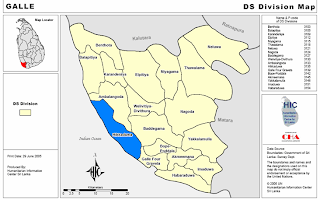
Local level warning dissemination: This will be the most effective way of warning dissemination in the suggested scenario. The Hikkaduwa DS Tsunami prone areas will be divided in to five zones for effective warning dissemination and evacuation. (Table 1 and Map 2). Each zone will have its distinctive warning dissemination mechanism with a responsible agency.

Table 1
Early-warning Zones in
Hikkaduwa Divisional Secretary Area
| Zone | Extent | Medium | Description |
| A | From Urawaththa upto Uduwaragoda South. | Police | Sirens, speakers mounted on the police jeeps and hand held megaphones will be used to warn the people. |
| B | From Daluwathumulla upto Seenigama. | Community Tsunami Early Warning Centre Loudspeaker Network | This community-based system has 15 loudspekaers. The speakers are manually operated from the 24/7 Community Tsunami Early-warning Centre, situated in Peraliya. |
| C | From Hikkaduwa town and upto Narigama | | This is a fully automated warning tower established by the Government. It covers a radius of 2.5 km. It can disseminate warning by siren as well as loudspeaker announcement. It can be activated from the Disaster management Centre in |
| D | From Thiranagama upto Uduhalpitiya. | Police | Sirens, speakers mounted on the police jeeps and hand held megaphones will be used to warn the people. |
| E | From Karawegoda upto Boossa. | Army Emergency Vehicles (Boossa Army Camp) | Sirens, speakers mounted on the army vehicles and hand held megaphones will be used to warn the people. |
In addition, in all zones, community volunteers will disseminate the message from the coastal line inwards as they are evacuating. This will be done on feet, by bicycles, motorbikes and three wheelers. Hand held megaphones or just shouting will be used.
In all zones, the traditional warning methods such as ringing of the temple, church and Kovil bells and announcement through mosque speakers will be used to inform the people.
2.2 Communication Strategies
According to the prior agreement with the telecommunication service providers in the area, measures to prevent congestion of the communication network will be implemented. Priority will be given for the bandwidth allocated for the emergency managers. Use of technologies like cell broadcasting will be made active from the EOC as soon as the emergency situation is declared to address the whole community without congestion.
Walky-talkies and radio communication networks of the police and army will be used for emergency communications. The Armature Radio network will also be utilized.
3. Evacuation Plan
The residents of the area will know the evacuation routes and shelters in their neighbourhood. Evacuation routes for different areas have already been identified and maps are available in the Yellow pages section of the phone directory. So any outside person (ex: a tourist) can turn to the yellow pages and find out where to evacuate. There are evacuation routes sign boards directing the evacuees. Again these will be of paramount use for strangers to the area.
3.1 How far to evacuate?
The inundation area for most of the areas of the HIkkaduwa DS had less than 1km affected by 2004Tsunami, 2 km area will be evacuated for safety reasons. (This was the practice during the two Tsunami evacuations in 2005 March and 2007 August).
Evacuation will be done through pre-identified, designated and rehearsed evacuation routes. There will be 3 types of evacuation routes:
1. Evacuation routes for vehicles.
2. Evacuation routes for pedestrians.
3. Evacuation routes for emergency service vehicles.
3.2 Evacuation routes for vehicles:
Effective evacuation of vehicles is important not only to protect the vehicles and their passengers, but also to minimize congestion and safe evacuation of pedestrians. Evacuation routes for vehicles will be used to evacuate the vehicles already on the
Up to 15 minutes from the initiation of the warning, vehicles will be directed to evacuate voluntarily along these routes. However, after 15 minutes of the initiation of the warning, road blocks will be enforced and all vehicles will be diverted by the volunteers along the evacuation routes.
Only roads more than 12 feet in width will be used to evacuate vehicles to minimize congestion. Paedestrinas will not be generally evacuated along these roads to prevent congestion as well as accidents.
Volunteer Groups from GN divisions inland will be called upon to direct the vehicles along alternative routes inland.
3.3 Coordination between Ambalangoda and
There will be close coordination between the emergency managers of the Ambalangoda and Galle Four Gravets emergency managers in directing the traffic as well as putting road blocks. This will help to prevent congestion both along the
3.4 Evacuation routes for pedestrians:
Vehicles will not be allowed to enter these roads. Pedestrians will be encouraged to use the closest evacuation route to where they are. They will be encouraged not to use the evacuation routes for vehicles. The pedestrians will be guided by the volunteers towards the evacuation shelters.
3.5 Evacuation routes for emergency service vehicles:
These few will be routes reserved for the emergency services vehicles such as police vehicles and ambulances. They will carry traffic in both directions. Sirens and roatating lights will be mounted on the emergency vehicles.
3.6 Needs of Special Groups:
The needs of the special groups such as elderly, disabled and bedridden people as well as pregnant mothers and children will be looked into primarily by the community itself. Exammple: Youth can be trained to carry a bed ridden person. In addition, the emergency service vehicles such as ambulance and police/army vehicles will help to evacuate pre-identified high risk individuals/groups needing assistance.
3.7 Role of police, forces and volunteers
It is important to guide the people properly for a safe evacuation unless evacuation itself could be a disaster! This was evident by following the evacuation of the 2005 March where many casualties and a couple f deaths were reported. The members of the of police and forces as well as the community volunteers will help the people to evacuate safely. The will provide the necessary information about evacuation routes, evacuation shelters etc.
There are many volunteer groups established under different umbrellas for different purposes. EX: Civil protection Committees, Disaster Management Centre GN level Volunteer Network, Community tsunami Early-warning Centre Volunteers, Sarvodhaya Volunteers etc. It is important to mobilize these different volunteer groups in an effective manner during and evacuation process.
3.8 Evacuation Zones
Evacuation zones will be the same as the Early-warning zones. The agency responsible for the early warning will assist the people in evacuation.


2
Evacuation Zones and Responsible Agencies
| Evacuation Zone | Responsible Agency |
| A | Meetiyagoda police |
| B | The Community Tsunami Early-warning Centre |
| C | Disaster Management Centre |
| D | Hikkaduwa hoteliers Association Life guard Service Hikkaduwa police |
| E | Boossa Army camp |
3.9 High Risk Areas
3.9.1 Zone D
Zone D covering the tourism area running from Hikkaduwa to Narigama will be considered as a high risk area. This is due to a number of reasons. This will be the busiest area at one a clock in the morning due to the concentration of the hotels in this area.
Though the exposure is less due to the presence of Coral Reefs and vulnerability is less due to the well-engineered structures in the area, from evacuation point of view, this will be high risk area. Majority of the tourists will be staying for a short period in the area and will not be familiar about the evacuation routes and shelters. In addition, there will be communication problems. Above all, It will be a sensitive area due to the large number of foreigners who are residing there and the repercussions that this area can have on the tourism.
Thus the evacuation will be under the purview of the Hikkaduwa Hoteliers Association supported by the Hikkaduwa police station and the life guards service.
3.9.2 Hikkaduwa Fishery Harbor
Almost all the fishing boats in the Hikkaduwa Fishery harbor were subjected to massive damage during the 2004 Tsunami claiming millions of Rupees. A contingency plan has been developed for the Hikkduwa Fishing harbor. The weather radio network of the
Boats with trailers in the harbor: To be moved outside the evacuation zone as soon as the warning is issued.
Boats in the sea: Keep ships off shore or move offshore (at least 1200feet deep) as soon as tsunami Warning is given deep. Move the ship at least 2 miles offshore from the coast.
If boats cannot evacuate either inland or offshore, most important goods can be removed within the allocated time period.
3.9.3 Hikkaduwa Town
If the Tsunami was to hit in the day time, Hikkaduwa town will be a high risk area due to concentration of the people in the government offices, schools, banks, bus stand and business premises in the Hikkaduwa town. In addition, all the schools in the area would have been high risk areas. However, at 1.00 am, none of these places will be high risk areas.
3.10 Vertical Evacuation
This is an acceptable option especially for engineered sturdy constructions such as large hotels in the area which survived the 2004. In addition some of the post Tsunami constructions have been designed for vertical evacuation. Ex: Hikkaduwa New police Station. Some of the foreigners may prefer to evacuate vertically in the comfort of the hotel instead moving inland. Prior plans have been made by the Hikkaduwa Hoteliers Association to guide foreigners who prefer to evacuate vertically to suitable structures.
Vertical evacuation will be the last option for those who cannot evacuate the area 15 minutes ahead of the expected first waves. In addition, police and Army personnel and volunteers will guard the area after the evacuation have to use the vertical evacuation shelters.
3.11 Evacuation Shelters
The pre-determined public evacuation shelters will be identified in each zone. Upon the declaring of an evacuation, the inland volunteer teams attached to these shelters will activate the public evacuation shelters. They will exercise the predetermined arrangements for the following:
· Reception of evacuees.
· Collection of information
· Arrange Television viewing and Radio listening facilities for evacuees
· Provision of emergency needs of the evacuees such as drinking water, refreshments and needs of special groups such as babies, children and lactating mothers.
· First aid
· Communication facilities with other evacuation shelters as well as the Disaster Management Centre.
In addition, families may evacuate to their relatives or friends places after getting out of the inundation zone.
Table 3
Countdown to First Wave
Schedule for Early-warning and Evacuation
| Time Elapsed from Receipt of Warning (minutes) | Time Count Down to expected First Wave (minutes) | Progress |
| 10 | 80 | Declare an emergency Emergency operations centre activated |
| 30 | 60 | Early-warning complete in Zones B and C Police and Army reached the coast line in Zones A,D,E Ships off shore warned not to return. |
| 40 | 50 | Early-warning complete in Zones A,D,E. Evacuation in progress in zones B and C. Road Breaks created. Vehicles diversion inland commenced. |
| 60 | 30 | Evacuation in Progress in all zones. |
| 70 | 20 | Ambulance/vehicle evacuation of bed ridden patients completed. |
| 75 | 15 | All the remaining people evacuated vertically |
| 80 | 10 | All volunteers are safe. |
| 90 | 0 | Tsunami first wave hits/does not hit |
| 120-180 | - | All clear warning given Return /response begins |
4 Post Evacuation Measures
The evacuated people will not be allowed to return to the inundation area until the all clear warning is issued by the Disaster Management Centre. The evacuated people will be continuously updated about the information provided by the Disaster Management Centre through the televisions and radio sets at the evacuation shelters.
Emergency needs of the evacuees will be provided such as drinking water, refreshments and needs of special groups such as babies, children and lactating mothers. First aid will be provided as required.
Post evacuation measures will lead to Emergency Response and Relief if a tsunami occurs. If no Tsunami occurs, the evacuees will be helped to return to the inundation area.
5 Recommendations
Some of the facilities and measures included in the above report are not available at present or needs to be strengthened. Thus the following recommendations are made to respond better to a similar scenario in the Hikkaduwa DS area:
1. To prepare the Hikkaduwa Emergency Preparedness and Response Manual assigning clear and specific instructions for various stakeholders in given scenarios.
2. Identify a suitable location (Ex: Meetiyagoda Police Station) and establish an Emergency Operations Centre and to upgrade its capacity to handle a future disaster.
3. Determine Early-warning and evacuation zones taking into consideration the diversity and the different levels of the early warning mechanism which are available in the area.
4. Strengthen the coordination and concerted effort of all the stake holders who have the capacity, commitment and authority to contribute towards disaster preparedness.
5. Prepare and publicize the inundation maps for the Hikkaduwa DS area and incorporate them in to decision making on public safety.
6. Obtain the participation and commitment of the telecommunications providers operating in the area to respond better in a given case scenario.
7. Prepare a detailed evacuation route and shelter map of the Hikkaduwa DS area and time schedules for different evacuation scenarios and to communicate them to the public. Ex: Yellow pages section of the telephone directories.
8. To put Tsunami evacuation sign boards along the evacuation roads.
9. Special groups needing assistance during evacuation Ex: bed ridden people, to be identified and documented.
10. Detailed Evacuation plans to be made for high risk areas such as the Zone D,
11. Vertical evacuation shelters to be identified and a special sign to be displayed in front of such buildings.
12. Evacuation shelters to be indentified and documented.
13. Strengthen the volunteer network both coastal and inland in order to respond better during an evacuation.
14. Conduct regular drills of early-warning and evacuation.
15. After obtaining permission from PGIS, to make this report available for decision makers in the Hikkaduwa DS area responsible for early warning and evacuation.
6. Acknowledgement
- Dr. K.P.P. Pathirana
- Cpt. Senarathna, District Disaster Management Coordinator, Galle District.
- United Nations Office for the Coordination of Humanitarian Affairs (for the Maps)
- The Manager, Coordinator and the officers of the Community Tsunami Early-warning Centre, Peraliya, Thelwaththa.
7. References
1. 3rd International Workshop on Coastal Disaster Prevention and Tsunami Hazad mitigation, 2007.
2. The Disaster Management Act 0f 2005.
3. UNDP, Galle District Disaster Management Plan, 2005.
4. Ministry of Disaster Management, Towards a Safer
5. Hawaii Civil Defence “Never try to surf a tsunami” (CD Rom).
6. Department of Land and Natural Resources,


No comments:
Post a Comment